> For the complete documentation index, see [llms.txt](https://docs.verge.aero/llms.txt). Markdown versions of documentation pages are available by appending `.md` to page URLs; this page is available as [Markdown](https://docs.verge.aero/drone-show-software/verge-web-portal/shows/site-maps.md).

# Site Maps

Build a briefing-ready site plan for a show — flight area, restricted zones, staging, crew and road closures — and get it cleared to render.

A **Site Map** is the plan of the physical show site: the flight area, restricted zones, staging and launch positions, audience, parking, emergency access, crew positions and road closures, drawn over satellite imagery and exported as a PDF with a legend, scale bar, north arrow and title block.

It is the artifact you hand to people who were not in the planning meeting — the FAA Flight Standards District Office on the 72-hour notice, the venue, local fire and police, and your own crew on show day. Because it is built from the show it describes, the drone count and altitude on the plan are the ones the rest of the portal already holds, rather than numbers copied across by hand.

Site maps also carry the **authorized flight area** — the airspace, ceiling and dates your show is cleared to fly in. This replaces the separate Flight Authorization step that existed previously.

## Creating a Show and its Site Map

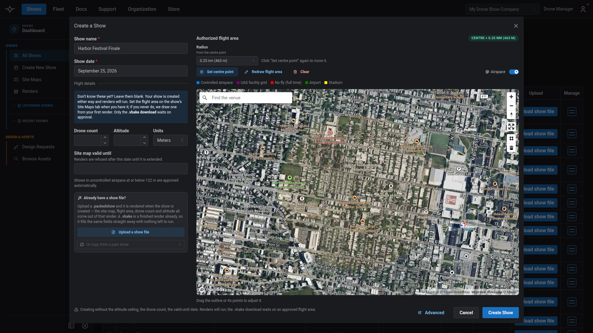
Click **Create New Show** — from the Shows workspace sidebar or the Shows table. The **Create a Show** modal opens in place, so you do not lose the page you were on. It asks for a name and a date, and gives you a map to set the flight area on.

The quickest way to set the area is to **drop a centre point and give it a radius** — the same way a NOTAM describes a flight ring. If you would rather trace the exact area, the polygon tool is one click away on the map's own toolbar.

If you already have a design file, use **Upload a show file** — or **Or copy from a past show** — instead.

* A **`.packedshow`** is your design. Upload it here and it is **rendered when the show is created, and its site map is built from that render** — the flight area, restricted zone, drone count and ceiling all come from the finished render, so you do not upload the same file again on the Renders tab. Nothing is drawn on the map at this point: the flight area comes from the render, which is the one source that always has it.
* A **`.vbake`**, or **copying from a past show**, is a render that already exists, so it fills the flight area, drone count and altitude straight away with nothing left to run. An imported area lands on the map fully editable, so you can adjust it rather than accept it as-is.

Choose **Advanced** if you want to fill in the rest of the show's details — venue, personnel, resources — at the same time.

<figure><img src="https://1654204364-files.gitbook.io/~/files/v0/b/gitbook-x-prod.appspot.com/o/spaces%2FakGR2bVCZLTNoe2hkqeR%2Fuploads%2Fgit-blob-1e7df974a15f24ffc58fb2b202393e4c7c9ba3ec%2Fcreate_show_modal.png?alt=media" alt=""><figcaption><p>The Create a Show modal, with the flight area set as a centre point and radius.</p></figcaption></figure>

## Rendering

**You do not need a flight area before you render.** If a show has no site map, submitting a render creates one for you, with a 1 km-wide ring centred on your launch point that you can refine afterwards.

Where a site map does already carry a flight area, two things are checked when you submit: the map has not passed its **valid until** date, and your launch positions sit inside the area. Neither can be checked when there is no area to check against, which is why an empty map does not block you.

{% hint style="warning" %}
**The flight area locks once a render succeeds.** This keeps a finished render matched to the airspace it was judged against. If the show moves, create a new site map — they are cheap. Dates stay editable either way, so a map that has expired can simply be extended.
{% endhint %}

## Review and downloading

Depending on how your organization is set up, site maps may be **reviewed by Verge** before renders can be downloaded. Where that applies:

* Renders still run as soon as you submit them. Review never holds up the work — only the download.
* A map that clears automatically is downloadable the moment the render finishes.
* You will be emailed when a render finishes, telling you whether it is ready or still with us, and again when a review clears, naming the renders it released.

Each map shows its state on the show's **Site Maps** tab and in the organization-wide list below.

## Your organization's site maps

**Shows → Site Maps** lists every site map your organization owns, so you are not opening shows one at a time to find the one holding up a download. It opens on a **Needs attention** filter — anything still a draft, awaiting or refused review, or past its valid-to date. Click a row to edit that map in place.

<figure><img src="https://1654204364-files.gitbook.io/~/files/v0/b/gitbook-x-prod.appspot.com/o/spaces%2FakGR2bVCZLTNoe2hkqeR%2Fuploads%2Fgit-blob-6f547a1a689d6e53d7a5d612e5d1b61ac34d8c7f%2Fsite_maps_org_list.png?alt=media" alt=""><figcaption><p>The organization-wide Site Maps list, filtered to maps needing attention.</p></figcaption></figure>

## Drawing the site plan

Open a site map from the show's **Site Maps** tab. The editor opens framed on your flight area and whatever is already drawn.

* Draw **polygons, rectangles, circles, lines and text**, each assigned a category that drives its colour and its legend entry.
* Add **dimensions** to any shape, set per-zone fill opacity, and use **hatching** to mark no-access areas.
* **Lock** an item so it cannot be moved by accident, and use copy/paste and keyboard shortcuts for repetitive work.
* Quick-add **Pilot in Command**, **Visual Observer**, **Security** and **Road Closure** markers. These group under **Crew** in the legend, and repeats collapse to a single entry such as *Visual Observer ×3*.
* Switch labels to **Number only** where the map is crowded — the full titles stay in the legend.

The authorized flight area is drawn in amber so it reads clearly over satellite imagery, and never shares a colour with a restricted zone.

<figure><img src="https://1654204364-files.gitbook.io/~/files/v0/b/gitbook-x-prod.appspot.com/o/spaces%2FakGR2bVCZLTNoe2hkqeR%2Fuploads%2Fgit-blob-9da8694fff0acea78d57c1b3e562c986c6c8e4c9%2Fsite_map_editor.png?alt=media" alt=""><figcaption><p>The site map editor, with the authorized flight area in amber and site zones drawn over it.</p></figcaption></figure>

### Tracing zones from a show file

Rather than tracing your flight area by hand, you can take it from the design itself. The geometry comes from the render engine's own flight paths, including its ballistic and wind projections, so it reflects where the drones actually go.

There are three routes:

1. **From a completed render.** Choose *Trace zones from show file* and pick any completed render in your organization — nothing to upload. Every finished render is offered, whatever the design file it started from contained, because the zones are taken from the render itself. Useful for an annual event at the same venue: start from last year's render.
2. **From a `.vbake` you upload.** For a render this portal does not hold — an older show, or one rendered elsewhere. Design files are not accepted here: the flight area and restricted zone are computed by the render engine, so a `.packedshow` carries them only if it was saved after a render, and not every one is. A `.vbake` always has them. To trace your own show, render it and use route 1.
3. **Automatically.** Tick *Create or update a site map when this render finishes* in the Upload Show File dialog. **Write into** decides where the zones land: the show's existing map by default — only previously traced zones are replaced, so anything you drew by hand is kept — or **A new site map**, which is what to choose when the show has moved. A new map also becomes the airspace the render is judged against, so a show at a new venue is not measured against the old venue's boundary.

Traced zones are ordinary editable shapes — adjust them as you would anything you drew. Re-tracing replaces only the zones that came from a show file, so your parking, crew positions and road closures survive.

<figure><img src="https://1654204364-files.gitbook.io/~/files/v0/b/gitbook-x-prod.appspot.com/o/spaces%2FakGR2bVCZLTNoe2hkqeR%2Fuploads%2Fgit-blob-d517961ef7e90f2a83a69ed84f2f1461fb0f2048%2Fsite_map_trace_from_show_file.png?alt=media" alt=""><figcaption><p>Tracing the flight area and restricted zone from a completed render.</p></figcaption></figure>

### Trace and buffer

A site plan usually needs more than one ring — a traced outline, and a margin around it. **Trace & buffer** builds the margin: point it at a zone you have selected or at the authorized flight area, pick **+5, +10, +25 or +50 m**, and choose the category for the result.

It always adds a new zone and keeps the original, which is the point — you end up with both rings, not a replaced one.

How much margin a site needs depends on the site, the crowd line, and what your FSDO will accept, which is why the buffer is a tool you point at an outline rather than a number the portal invents for you.

<figure><img src="https://1654204364-files.gitbook.io/~/files/v0/b/gitbook-x-prod.appspot.com/o/spaces%2FakGR2bVCZLTNoe2hkqeR%2Fuploads%2Fgit-blob-ce977ccd8b1aec0d1d46a76f7bd85666c7840d81%2Fsite_map_trace_and_buffer.png?alt=media" alt=""><figcaption><p>Trace &#x26; buffer, building a margin ring around the authorized flight area.</p></figcaption></figure>

## Exporting the PDF

Export from the editor header. You can frame the export to **all content** or to your **current map view**, in portrait or landscape, and choose where the legend and title block sit.

The title block carries the show's details, your on-site contacts (pulled from the show's personnel), and your organization's logo — or a different image per map, if you upload one. Long venue addresses no longer truncate: choose whether the location reads as an address, a venue name, coordinates, or address plus coordinates.

The **Authorized Flight Area** is always drawn and always takes the first row of the legend, under that exact label, whatever you named the zone you drew — so a reader looking for the airspace the plan is about finds it without interpreting your legend.

<figure><img src="https://1654204364-files.gitbook.io/~/files/v0/b/gitbook-x-prod.appspot.com/o/spaces%2FakGR2bVCZLTNoe2hkqeR%2Fuploads%2Fgit-blob-2b816ec6fc7786b6a35fbd6e0ed23c85e629109f%2Fsite_map_pdf_export.png?alt=media" alt=""><figcaption><p>An exported site plan, with the authorized flight area first in the legend.</p></figcaption></figure>

## Troubleshooting

| What you see                                                   | What it means                                                                                                                                                                                                                  |
| -------------------------------------------------------------- | ------------------------------------------------------------------------------------------------------------------------------------------------------------------------------------------------------------------------------ |
| **"No renders with traceable zones"**                          | Nothing in your organization has finished a render yet. Renders from before September 2026 can also be missing here if the design file they were given carried no zones of its own — re-render the show and it will be listed. |
| **"Zones are traced from a render, so this needs a `.vbake`"** | You picked a design file. A `.vbake` always carries the flight area and restricted zone; a design file only does if it was saved after a render. Render the show and trace from the render instead.                            |
| **"This file has no traceable geometry"**                      | The `.vbake` carries no zones — an engine version that predates them, or a file that is not a render output.                                                                                                                   |
| **Restricted zone missing after tracing**                      | The render's engine version predates restricted zones. Use the computed option, or re-render on a current version.                                                                                                             |
| **Zones in the wrong place**                                   | Check the render you picked belongs to this venue — the picker shows how far each option is from the show's location.                                                                                                          |
| **A render will not submit**                                   | The site map has passed its valid-to date, or your launch positions fall outside the flight area. Extend the dates, or widen the area.                                                                                         |
| **A render will not download**                                 | The map is awaiting review, or was refused. The Site Maps list shows which, and you will be emailed when it clears.                                                                                                            |
| **The flight area cannot be edited**                           | It locked when a render succeeded against it. Create a new site map to fly a different area; dates can still be changed.                                                                                                       |

***

For the rest of the production lifecycle, see [Creating and Rendering](/drone-show-software/verge-web-portal/shows/creating-and-rendering.md) and [Logistics, Collaboration, and Coordination](/drone-show-software/verge-web-portal/shows/logistics-collaboration-and-coordination.md).
